About Me

Hi, my name is Naser Ahmed and welcome to my website. I am a second-year master's student in Geographic Information Science (GIS) at the Department of Geography and Environment, Western University, awarded with the Western Graduate Research Scholarship. Title of my thesis: Transportation and Land Use Planning for Healthy Cities. I am also working as a GIS associate in the Human Environments Analysis Laboratory (HEAL) at Western, where I am contributing to the ParkSeek project. Additionally, I serve as a teaching assistant at Western University, where I teach GIS and Remote Sensing.

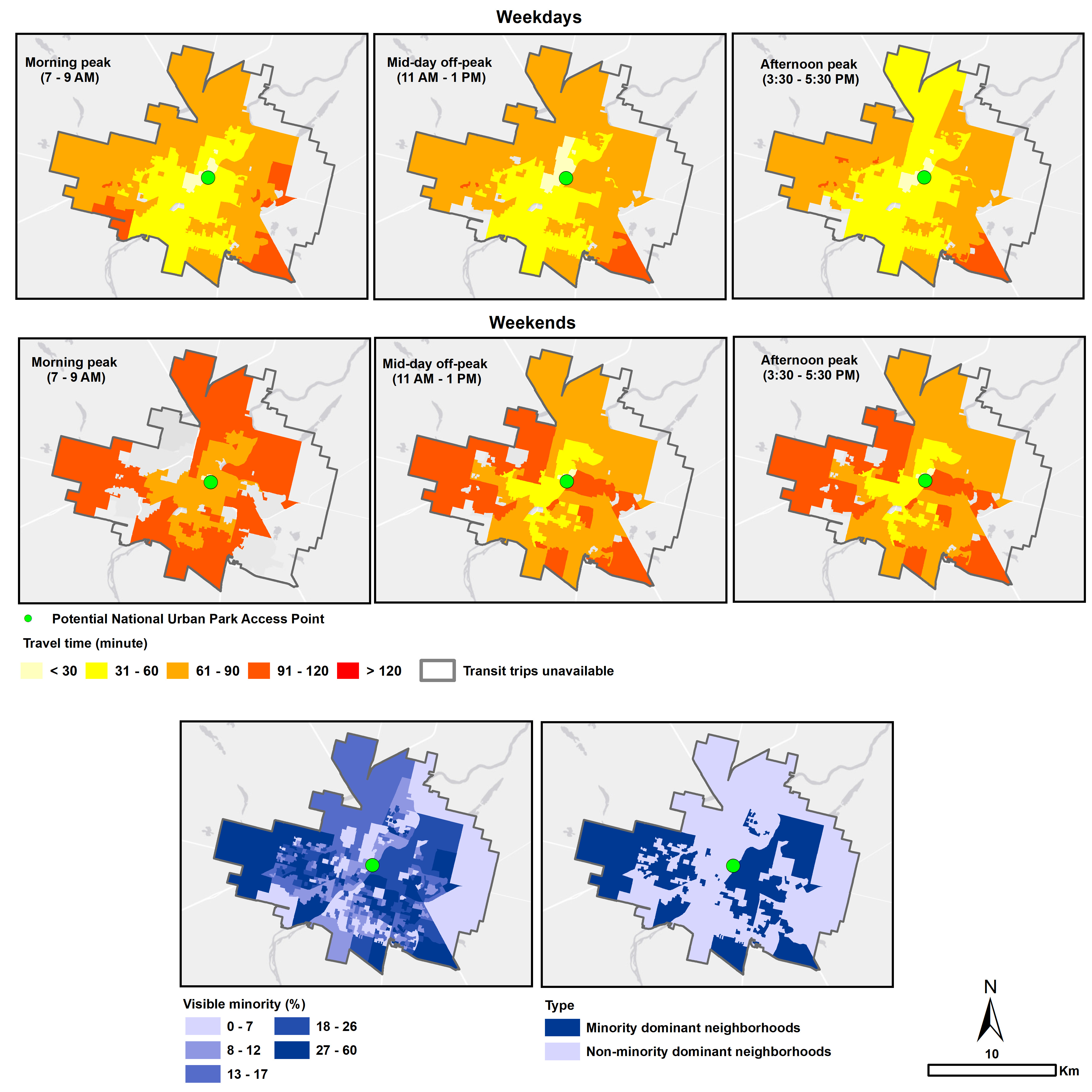
Recently, I worked as a lead research assistant in the Parks Canada General Class Grants and Contributions Program, where I successfully completed a project focused on conducting a social equity analysis of public transit-based accessibility to candidate National Urban Parks (NUPs) in 15 cities across Canada. I am primarily interested in transportation planning and is dedicated to promoting sustainable and healthy public transit systems. Check out my awesome work.

Research interest

My research interests lie in the field of transportation geography, urban planning, public health, GIS, and Remote Sensing. I am committed to exploring ways to create sustainable and resilient mobility from an equity perspective. My research questions focus on three key areas: 1) sustainability, 2) accessibility, and 3) social equity.

Empirical: Accessibility, mobility, sustainable transportation and social equity, and healthy cities.

Methodological: Geographic information science, Remote Sensing, Spatial Statistics.

Skills and software: GIS, spatial data science, transportation planning, R, Python, HTML, ArcGIS, QGIS, satellite image application.

If you ever want to see me, you can find me here:

Cost of Climate Change

Public transit offers urban populations physical accessibility to resources and opportunities. However, at the same time, transit trips often expose users to extreme environmental conditions, such as extreme heat and cold since transit journeys usually include out-of-vehicle trip segments including walking and waiting. Such exposure can be considered as environmental health costs because exposure to weather extremes can lead to adverse health outcomes. Even worse, climate change is increasing the intensity and frequency of extreme weather events. In this context, how can we make public transit accessibility measures ready for climate change? This project answers the question by developing a general cost function approach combining travel time and environmental health costs into an integrated measure of dual accessibility: a measure of the travel costs of accessing a fixed number of destinations. We synthesize transport science, environmental health, remote sensing, and urban climatology to empower the proposed framework. To demonstrate the utility of the proposed method, we carry out an example study that incorporates transit passengers' extreme cold exposure into accessibility measures in the city of Winnipeg, Manitoba, Canada. Further, we perform a social equity analysis to investigate whether the increase in total integrated costs (i.e., decrease in accessibility) due to the inclusion of environmental health costs disproportionately affects socially disadvantaged population groups. The proposed method enables a more realistic and practical measurement of public transit accessibility under climate change; thereby, improving the readiness and resilience of our society and transport systems for future challenges.

This project is a part of my master's thesis and was funded by SSHRC Expore Grant. PI: Professor Jinhyng Lee

Transit to National Urban Parks

In 2021, the Government of Canada committed to establishing up to 15 national urban parks (NUPs) in every province and territory by 2025 to better ensure that Canadians have access to greenspace and, by extension, support public health and well-being. Given that geographic accessibility to candidate NUPs might be disproportionally distributed within cities, it is important to assess how various aspects of social equity, including transit-based accessibility, can be effectively linked to NUP planning. To address this gap, we evaluate the geographic accessibility of the 15 candidate NUPs based on public transit through a transportation and environmental justice lens. Specifically, we perform a social equity analysis to investigate whether there are statistically significant differences in transit-based accessibility to NUPs between minority- versus non-minority population-dominant neighbourhoods.

This project was funded by Parks Canada: General Class Grants and Contributions Program. PI: Professor Jinhyng Lee

ParkSeek

During my graduate studies at Western, I had the opportunity to work as a GIS associate on an exciting project called ParkSeek. The overarching goal of the ParkSeek project is to build a platform for Canadian-specific research and practice related to the interconnections between population health and parks and recreational facilities.

This project was funded by Public Health Agency of Canada.

geographic accessibility to

emergency cyclone shelters

This research aims to explore the inequalities and vulnerabilities in geographic accessibility to emergency cyclone shelters in Bangladesh, a country in the Global South that is prone to natural disasters. We first quantify walking time to the nearest cyclone shelters as a basic measure of accessibility. Additionally, we compute a more practical measure of accessibility by considering crowding effects in shelters due to the interactions between supply (e.g., shelter capacity) and demand (e.g., population levels) using the two-step floating catchment area (2SFCA) method. We examine accessibility inequalities through the Gini index. Furthermore, we perform a vulnerability analysis with an equity lens to examine whether marginalized populations are disproportionately located in vulnerable areas with insufficient accessibility. The results indicate substantial inequalities in 2SFCA-based cyclone shelter accessibility across different regions. The vulnerability analysis results reveal that seniors, females, individuals with physical disabilities, and religious minorities are disproportionately located in areas requiring more than the government guideline of 20 minutes walking time to the nearest shelters. This study is one of the first attempts to understand the inequalities and vulnerabilities in geographic accessibility to emergency cyclone shelters in an under-examined low- and middle-income country (LMIC) in the Global South like Bangladesh. By shedding light on the inequalities and vulnerabilities faced in accessing these critical facilities, our research contributes to the broader understanding of human mobility and accessibility in response to the increasing intensity and frequency of unexpected disruption events in the context of climate change.

This project was partially funded by SSHRC Expore Grant. PI: Professor Jinhyng Lee

urban green space deserts

A lingering question in the research on urban green space (UGS) availability in the Global South is which walking distance threshold should be used due to the absence of consensus on that in the literature and planning guidelines. This paper answers that question by developing an analytical framework for identifying UGS deserts - areas without adequate UGS availability level - considering various walking distance thresholds. We first demonstrate how geographic distributions of UGS deserts can change depending on different walking distance thresholds (e.g., 100, 300, 500 m) of choice. Unreliable and inaccurate detection of UGS deserts can hinder evidence-based land use planning for promoting healthy cities and result in erroneous social equity evaluation. To overcome this limitation, we introduce and examine robust UGS oases and deserts: geographic areas with and without the per capita green space (PCG) level recommended by a local government regardless of different walking distance thresholds used, respectively. With the identified robust UGS deserts and oases, we perform a social equity analysis to investigate inequality and whether there are systematic disadvantages for socioeconomically vulnerable populations to access UGS in Dhaka, a rapidly developing capital city in Bangladesh. The robust UGS deserts approach enables more reliable and informed decision-making to enhance UGS availability and its social equity, thereby facilitating an optimal development of urban policy for healthy cities. More practically, our robust UGS deserts method can be an effective alternative to detect UGS deserts when guidelines for walking distance thresholds are missing which is often the case in low- and middle-income countries.

This project is a part of my master's thesis. Read full paper here.

Other projects

I started my GIS career as a remote sensing analyst, and the core focus of my research was using GIS and remote sensing to assess and predict the risks and vulnerability of natural hazards, such as coastal erosion, cyclones, flooding, etc.

Here are some examples. If you are more interested read here.

Publications

Google Scholar

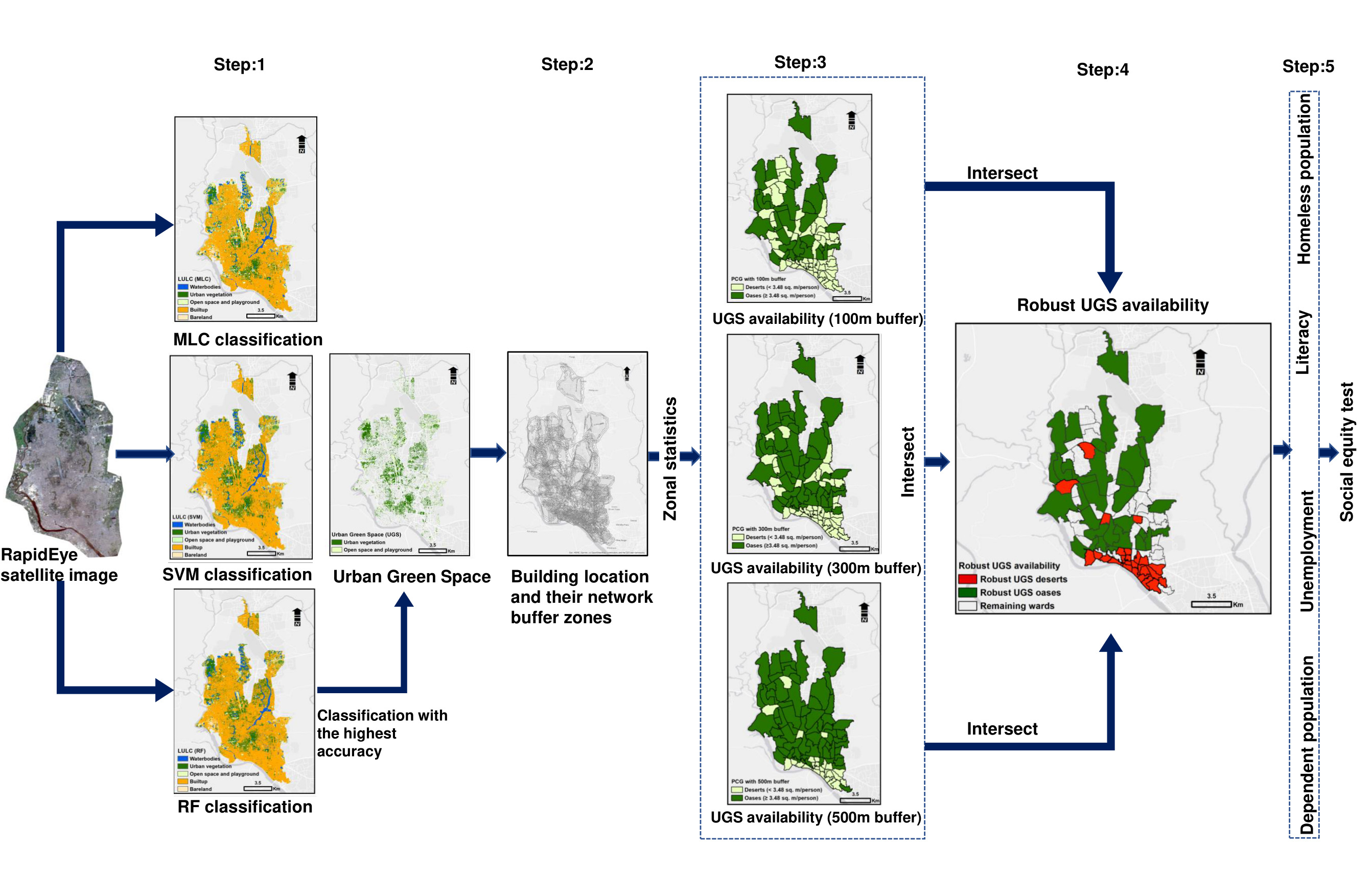
1. Ahmed, N., Lee, J., Liu, D., Kan, J., Wang. J. (2023). Identifying urban green space deserts by considering different walking distance thresholds for healthy city planning in the Global South. Urban Forestry and Urban Greening, Elsevier, 128123. [Full Link]

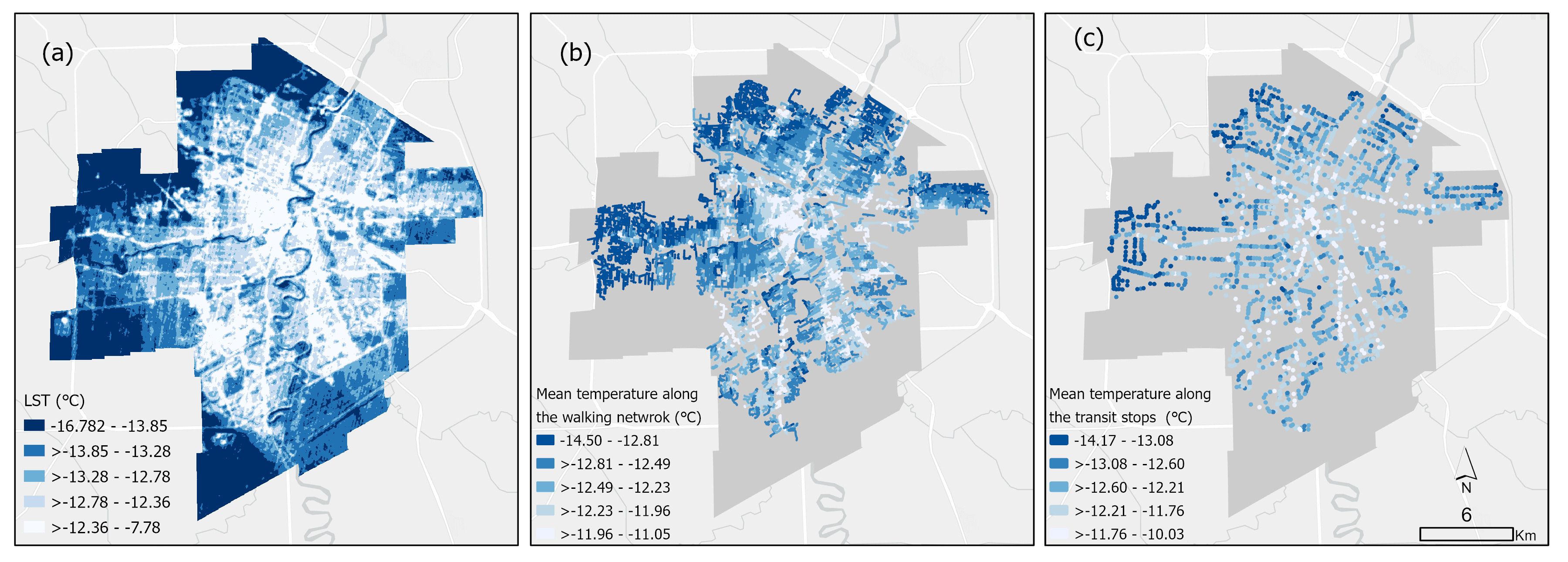
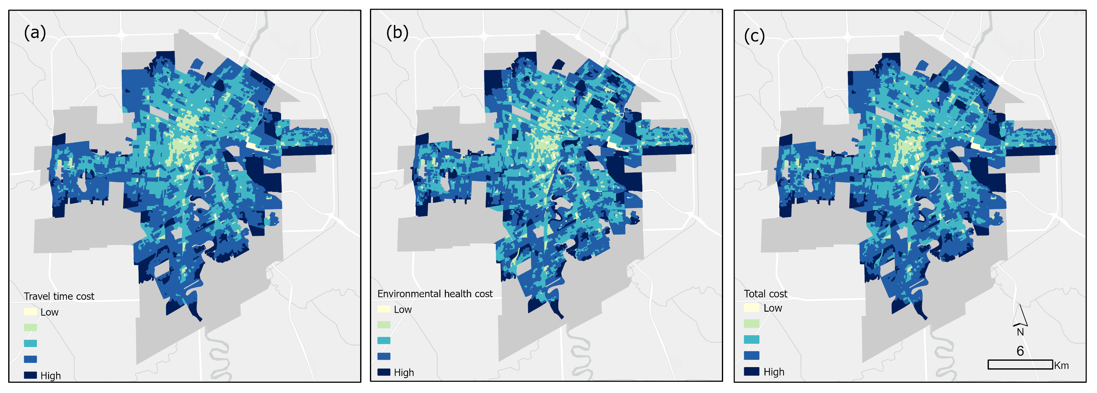
2. Ahmed, N., Lee, J., Kim, J., Wang. J. (2023). The cost of climate change: A general cost function approach for incorporating extreme weather exposure into public transit accessibility., Computers, Environment and Urban Systems, Elsevier. [Under Review]

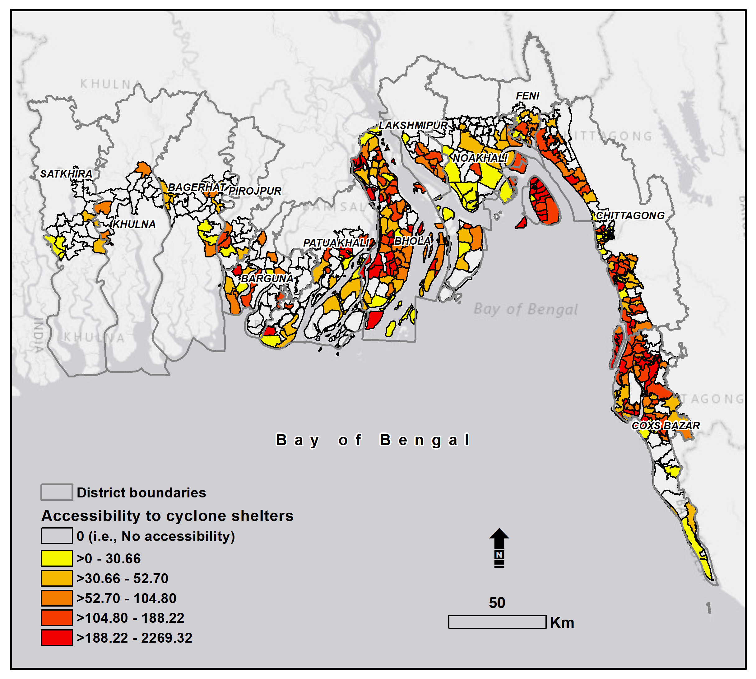
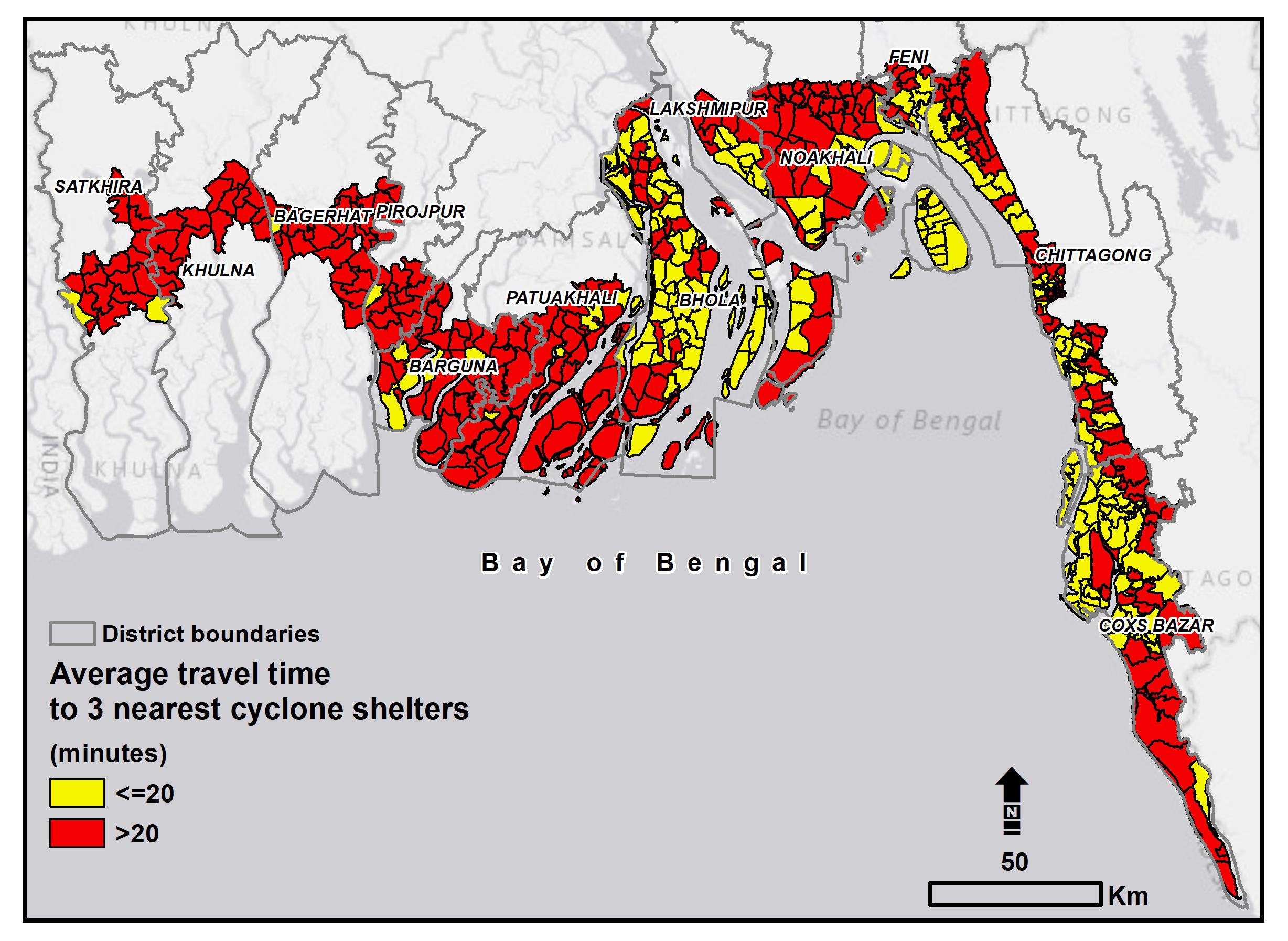
3. Ahmed, N., Jui, J., Liu, D., Kim, K., Kim, J., Lee, J. (2023). Inequality and vulnerability analysis of geographic accessibility to emergency cyclone shelters in a cyclone-prone country of the Global South under climate change. Journal of Transport Geography, Elsevier. [Under Review]

4. Ahmed, N., Hoque, M.A.A., Arabameri, A., Pal, SC., Chakrabortty, R., & Jui, Jesmin. (2022). Flood susceptibility mapping in Brahmaputra floodplain of Bangladesh using deep boost, deep learning neural network, and artificial neural network. Geocarto International, Taylor & Francis. [Full Link]

5. Ahmed, N., Hoque, M.A.A., Howlader, N., & Pradhan, B. (2021). Spatial flood risk assessment in the northwestern part of Bangladesh using multi-criteria techniques. Geocarto International, Taylor & Francis. [Full Link]

6. Ahmed, N., N. Hoque, M.A.A., Pradhan, B. & Arabameri, A. (2021). Spatio-temporal Assessment of Groundwater Potential Zone in the Drought-Prone Area of Bangladesh Using Different GIS-Based Bivariate Models. Natural Research Resource, Springer. [Full Link]

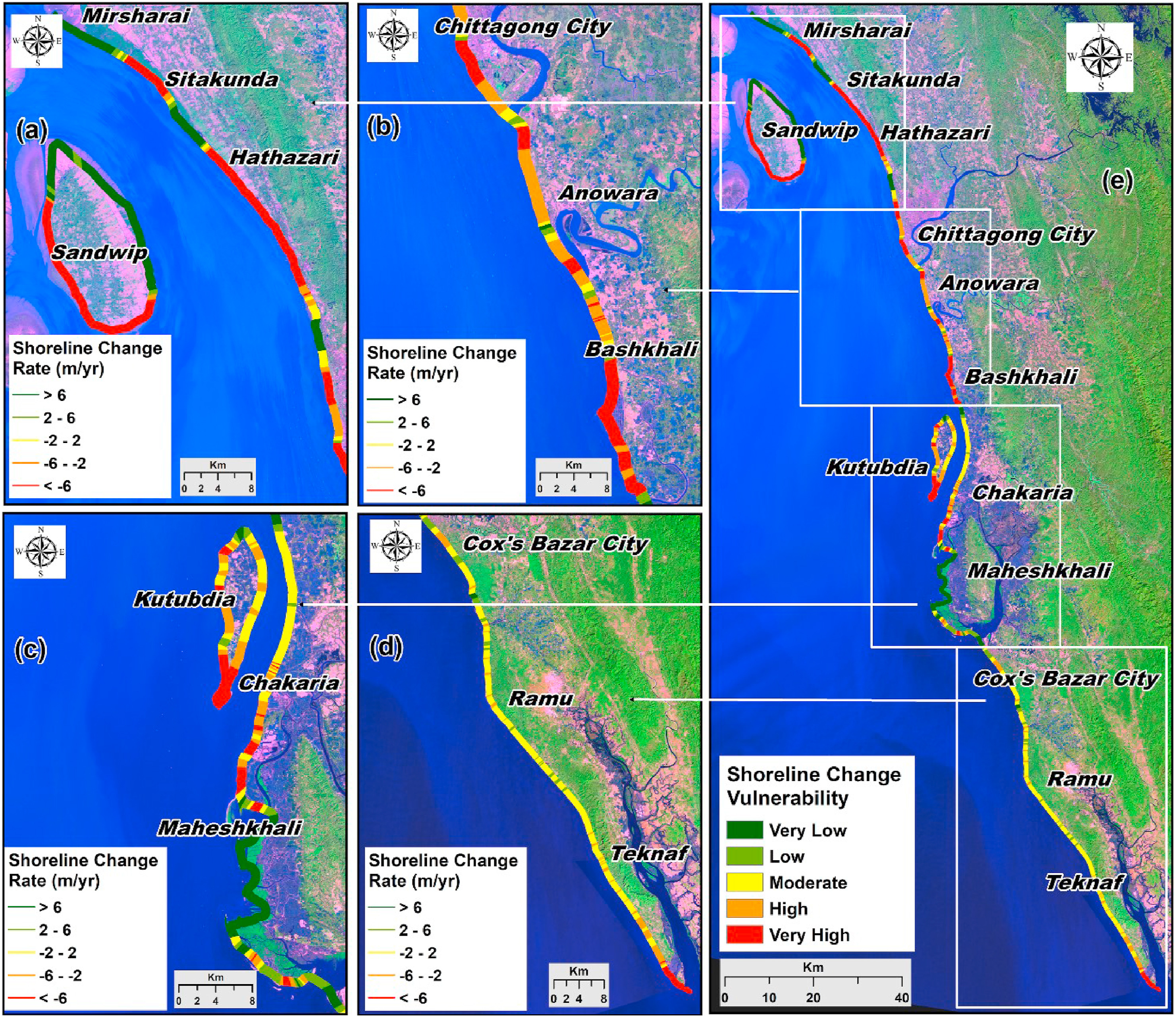
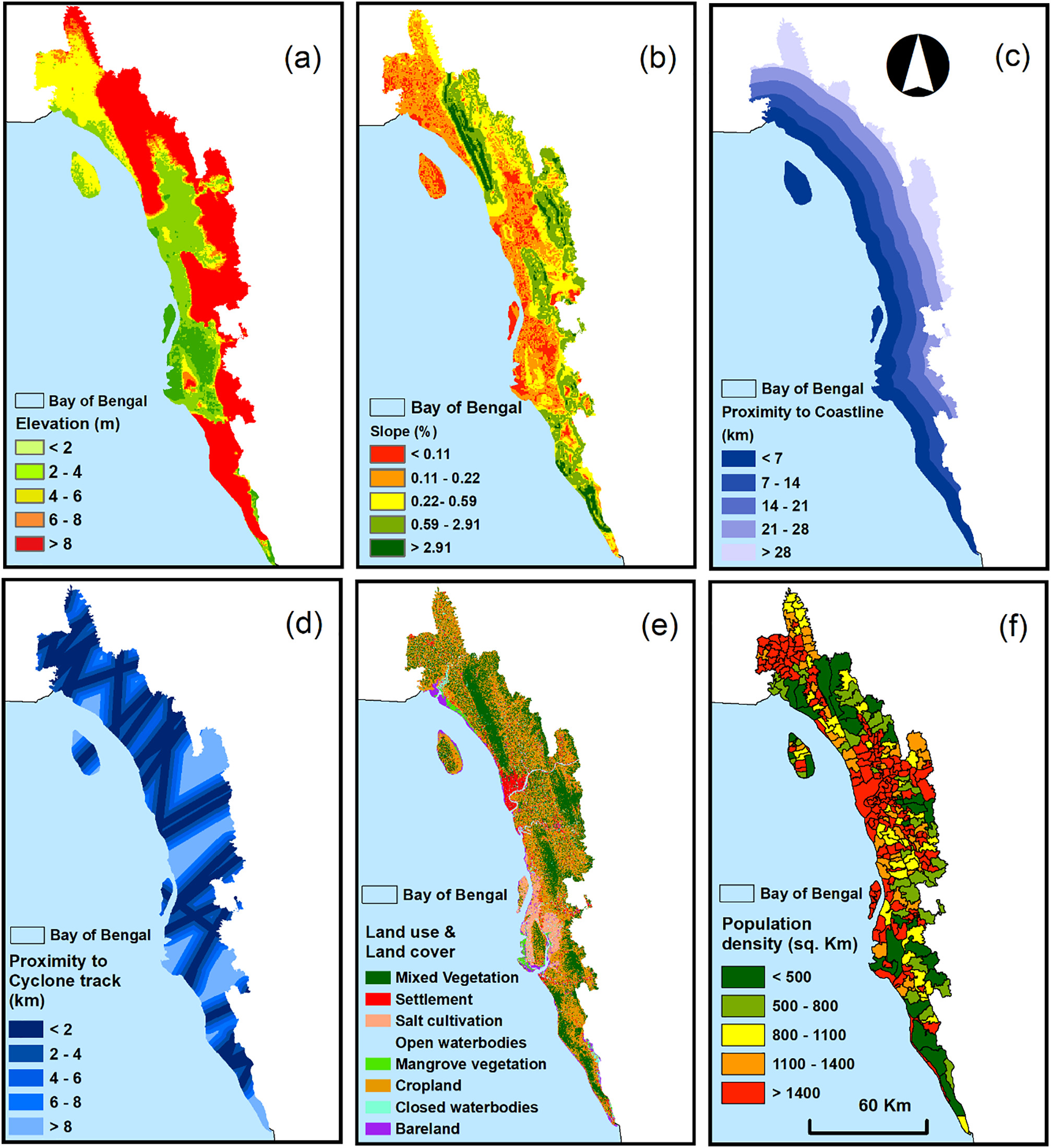
7. Ahmed, N., Howlader, N., Hoque, M.A.A. & Pradhan, B. (2021). Coastal erosion vulnerability assessment along the eastern coast of Bangladesh using geospatial techniques. Ocean & Coastal Management, Elsevier, 105408. [Full Link]

8. Hoque, M.A.A., Pradhan, B., Ahmed, N., Sohel, M.S.I. (2021). Agricultural drought risk assessment of Northern New South Wales, Australia using geospatial techniques. Science of the Total Environment, Elsevier, 143600. [Full Link]

9. Hoque, M.A.A., Pradhan, B., Ahmed, N. (2021). Drought vulnerability assessment using geospatial techniques in Southern Queensland, Australia. Geomatics, Natural Hazards and Risk, Taylor & Francis, 12. [Full Link]

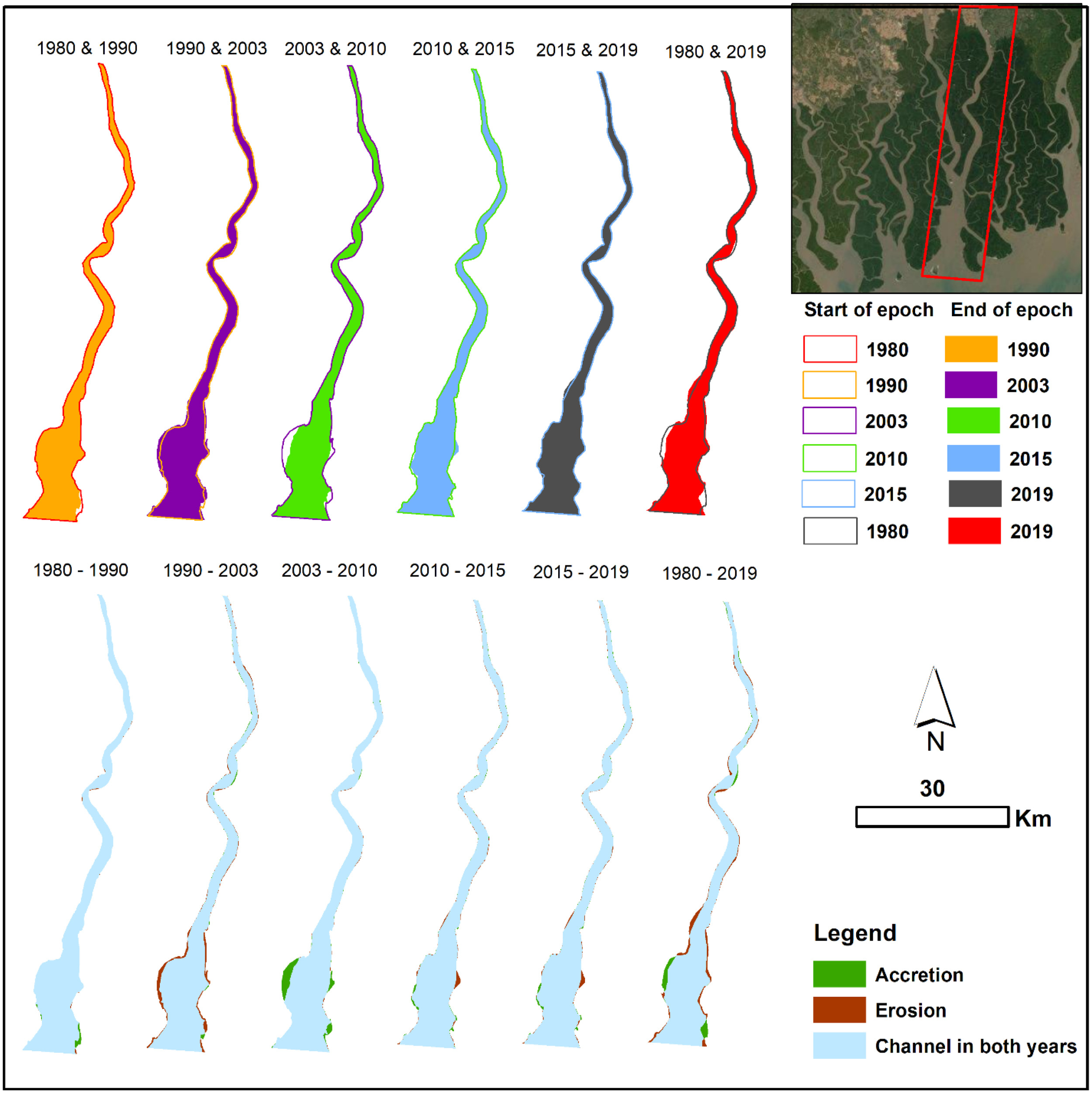
10. Roy, S., Pandit, S., Papia, M., Ocampo, J.C.O.R., Razi, M.A., Fraile-Jurado, P., Ahmed, N., Hoque, M.A.A., Hasan, M.M., Yeasmin, J., Hossain, M.S. (2021). Coastal erosion risk assessment in the dynamic estuary: The Meghna estuary case of Bangladesh coast. International Journal of Disaster Risk Reduction. Elsevier. [Full Link]

11. Hoque, M.A.A., Pradhan, B., Ahmed, N., Ahmed, B., Alamri. A.M. (2021). Cyclone vulnerability assessment of the western coast of Bangladesh. Geomatics, Natural Hazards and Risk, Taylor & Francis, 12. [Full Link]

12. Sohel, M.S.I., Hore, S.L., Salam, A.S., Hoque, M.A.A., Ahmed, N., Rahman, M.R., Khan, H.M., Rahman, S. (2021) Satellite images reveals erosion-accretion dynamics of major rivers of the Bangladesh Sundarbans. Regional Studies in Marine Science, Elsevier. [Full Link]

13. Hoque, M.A.A., Pradhan, B., Ahmed, N. (2020). Assessing drought vulnerability using geospatial techniques in northwestern part of Bangladesh. Science of the Total Environment, Elsevier, 135957. [Full Link]

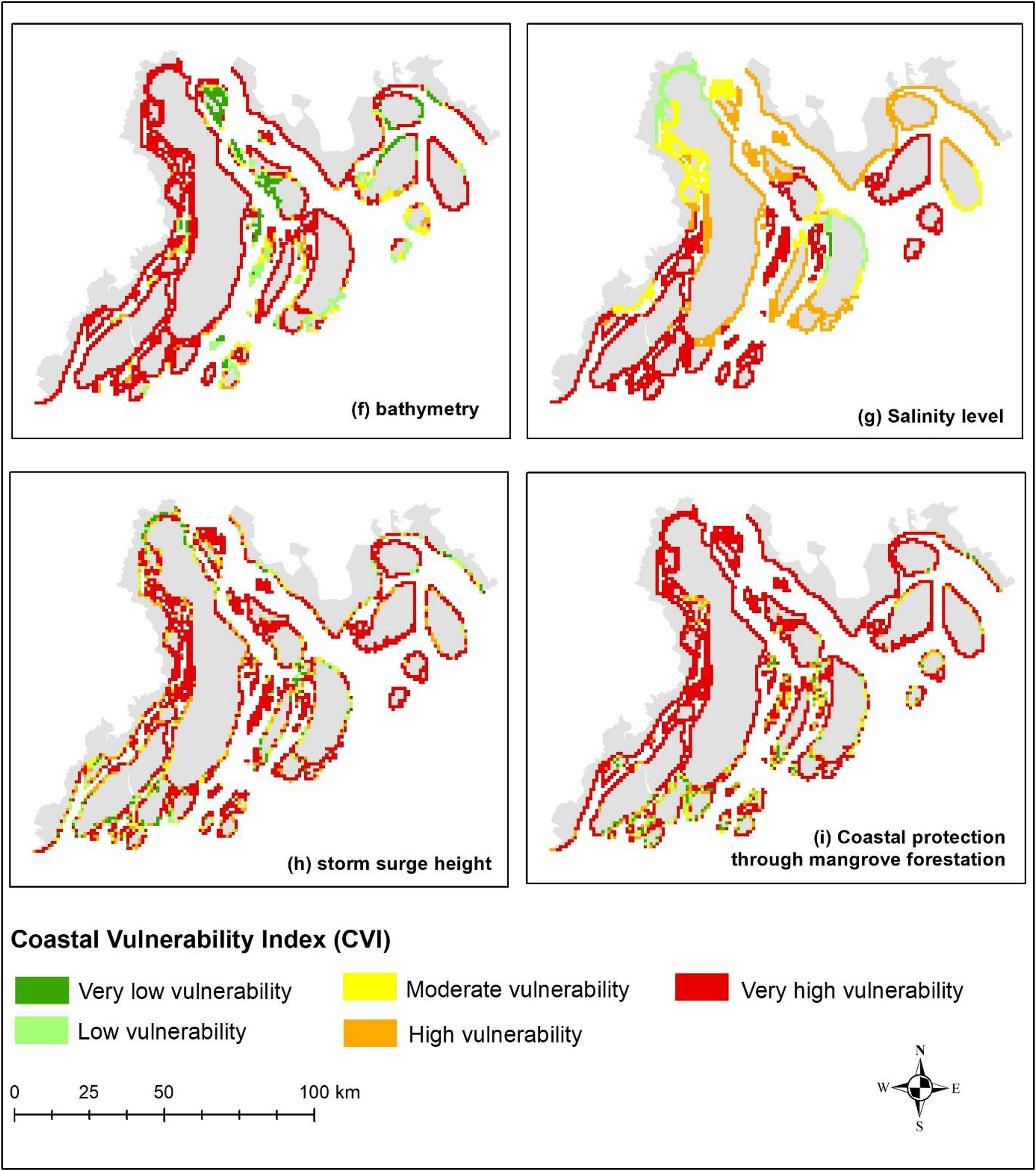
14. Mahmood, R., Ahmed, N., Zhang, L., Li, G. (2020). Coastal Vulnerability Assessment of Meghna Estuary of Bangladesh using Integrated Geospatial Techniques. International Journal of Disaster Risk Reduction, Elsevier, 42. [Full Link]

15. Hoque, M.A.A., Pradhan, B., Ahmed, N. & Roy, S. (2019). Tropical cyclone risk assessment using geospatial techniques for the eastern coastal region of Bangladesh. Science of the Total Environment, Elsevier, 692, pp. 10-22. [Full Link]

16. Hoque, M.A.A., Tasfia, S., Ahmed, N., & Pradhan, B. (2019). Assessing Spatial Flood Vulnerability at Kalapara Upazila in Bangladesh Using an Analytic Hierarchy Process. Sensors, MDPI, 03/2019; 2019(19):1302. [Full Link]

17. Hoque, M.A.A., Ahmed, N., Pradhan, B. & Roy, S. (2019). Assessment of coastal vulnerability to multi-hazardous events using geospatial techniques along the eastern coast of Bangladesh. Ocean & Coastal Management, Elsevier, 181 (104898), pp. 1-17. [Full Link]

Education

MSc. in GIScience, 2022 - Present

Geography and Environment, Western University

  • Thesis: Transportation and Land Use Planning for Healthy Cities.

MSc. in Remote Sensing, 2018 - 2019

Geography and Environment, Jagannath University

  • Thesis: Spatial flood risk assessment in the northwestern part of Bangladesh using multi-criteria techniques.

BSc., 2014 - 2018

Geography and Environment, Jagannath University

  • Thesis: Coastal erosion vulnerability assessment along the eastern coast of Bangladesh using geospatial techniques.

Research Experience

GIS Associate, 2023 - Present

Human Environments Analysis Laboratory (HEAL), Western University

  • Project: ParkSeek. Funded by Public Health Agency of Canada (PHAC).

Research Assistant, 2023 (Summer)

Western University

  • Project: Social equity analysis of public transit users’ exposure to weather extremes. Funded by: SSHRC Explore Grant.

Research Assistant, November 2022 - April 2023

Wilfrid Laurier University

  • Project: Social equity analysis of public transit-based accessibility to candidate national urban parks in Canada. Funded by Parks Canada: General Class Grants and Contributions Program.

GIS Assistant, September 2022 - October 2022

Map and Data Centre, The D.B. Weldon Library, Western University

  • Project: Historical Fire Insurance Plan.

Research Assistant, January 2022 - August 2022

Western University

  • Project: A social equity analysis of neighbourhood vulnerability to urban flooding in Canadian cities. Funded by SSHRC Explore Grant.

Research Assistant, 2018 - 2021

Jagannath University

  • Project: Modelling and measuring natural hazards risks in Bangladesh. Funded by Ministry of Science and Technology, Bangladesh.

Teaching Experience

Teaching Assistant, 2022 - Present

Department of Geography and Environment, Western University

  • GEOG 2220B: Geographic Information Science
  • GEOG 2230B: Remote Sensing
  • GEOG 2152F: Geography of Hazards

Course taught as a guest lecturer

Department of Geography and Environment, Western University

  • GEOG 3222A: Geographic Information Science II (for Dr. Jinfei Wang)
  • GEOG 3225B: Transportation Geography and GIS (for Dr. Jinhyung Lee)
  • GEOG 3226A: Urban Data Science (for Dr. Jinhyung Lee)
  • GEOG 2230B: Remote Sensing (for Dr. Jinfei Wang)

Student mentored, summers of 2022 and 2023

Undergraduate Student Research Internship (USRI) project, Western University

  • Armin Mahboubi
  • Taylor Echeverria

Honors and Awards

  • Western Graduate Research Scholarship (WGRS) covers full tuition by Western University, 2023
  • Travel Grant Award by Western University, 2023
  • Best Student Paper Award, Centre for Research on Social Inequality (CSRI), 2023
  • Summer School, University of Toronto, 2023
  • National Science and Tenchnology Fellowship, Ministry of Science and Technology, Bangladesh, 2019
  • Scholarship to support undergrad tution, Jagannath University, 2014-2018

Services

  • Distinguished Lecture & Workshop Committee, Geography and Environment, Western University
  • ECCE Student Associate, ESRI, Canada
  • Manuscript Reviewer, Sustainable Cities and Societies (Elsevier)
  • Manuscript Reviewer, Science of the Total Environment (Elsevier)
  • Manuscript Reviewer, International Journal of Disaster Risk Reduction (Elsevier)
  • Manuscript Reviewer, Geomatics, Natural Hazards and Risk (Taylor & Francis)
  • Manuscript Reviewer, Heliyon (Elsevier)
  • Member, American Association of Geographers (AAG)
  • Member, Centre for Research on Social Inequality (CSRI)
  • Member, Alumni Association, Jagannath University

Elements

Text

This is bold and this is strong. This is italic and this is emphasized. This is superscript text and this is subscript text. This is underlined and this is code: for (;;) { ... }. Finally, this is a link.


Heading Level 2

Heading Level 3

Heading Level 4

Heading Level 5
Heading Level 6

Blockquote

Fringilla nisl. Donec accumsan interdum nisi, quis tincidunt felis sagittis eget tempus euismod. Vestibulum ante ipsum primis in faucibus vestibulum. Blandit adipiscing eu felis iaculis volutpat ac adipiscing accumsan faucibus. Vestibulum ante ipsum primis in faucibus lorem ipsum dolor sit amet nullam adipiscing eu felis.

Preformatted

i = 0;

while (!deck.isInOrder()) {
    print 'Iteration ' + i;
    deck.shuffle();
    i++;
}

print 'It took ' + i + ' iterations to sort the deck.';

Lists

Unordered

  • Dolor pulvinar etiam.
  • Sagittis adipiscing.
  • Felis enim feugiat.

Alternate

  • Dolor pulvinar etiam.
  • Sagittis adipiscing.
  • Felis enim feugiat.

Ordered

  1. Dolor pulvinar etiam.
  2. Etiam vel felis viverra.
  3. Felis enim feugiat.
  4. Dolor pulvinar etiam.
  5. Etiam vel felis lorem.
  6. Felis enim et feugiat.

Icons

Actions

Table

Default

Name Description Price
Item One Ante turpis integer aliquet porttitor. 29.99
Item Two Vis ac commodo adipiscing arcu aliquet. 19.99
Item Three Morbi faucibus arcu accumsan lorem. 29.99
Item Four Vitae integer tempus condimentum. 19.99
Item Five Ante turpis integer aliquet porttitor. 29.99
100.00

Alternate

Name Description Price
Item One Ante turpis integer aliquet porttitor. 29.99
Item Two Vis ac commodo adipiscing arcu aliquet. 19.99
Item Three Morbi faucibus arcu accumsan lorem. 29.99
Item Four Vitae integer tempus condimentum. 19.99
Item Five Ante turpis integer aliquet porttitor. 29.99
100.00

Buttons

  • Disabled
  • Disabled

Form